Every Treasure Island renter has the right to know what radiation, chemicals and heavy metals lie inside, beneath and in the common areas between their homes
by Carol Harvey
Part One of this series ended with the question: Was the new signage that appeared on Treasure Island townhouses in spring 2019 a cruel withdrawal of the Navy’s former guarantees that living on the island is safe? Was the Navy reversing course and admitting the poisonous truth: Treasure Island is toxic?
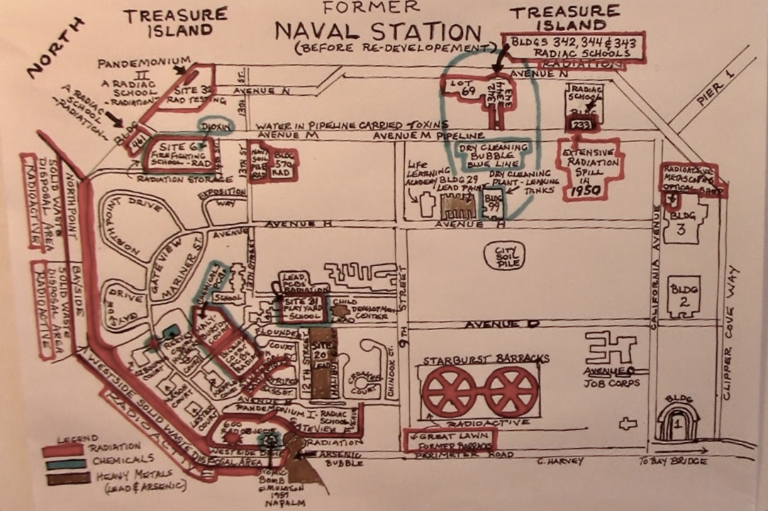
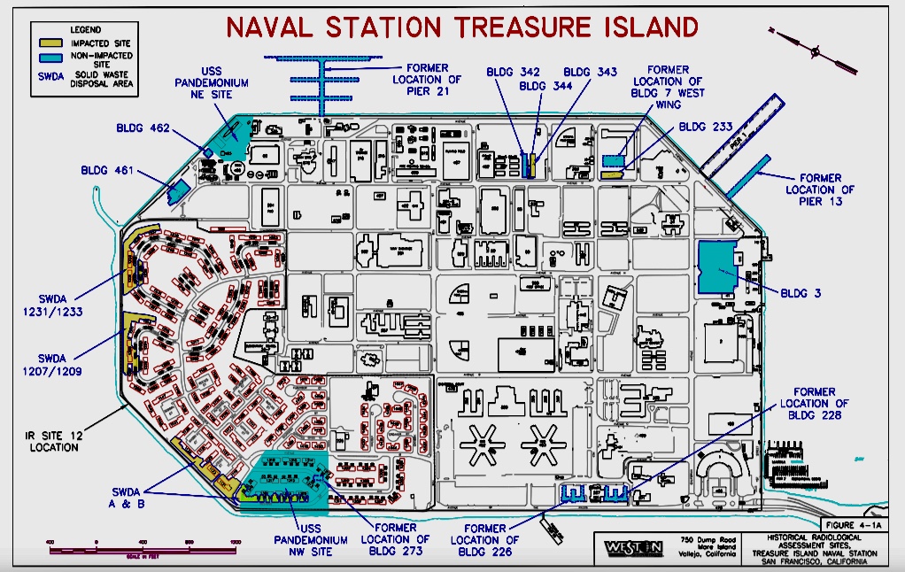
Treasure Island’s toxicity has been well-documented by the Navy
A 2016 Navy leaflet excerpted below stated that from 1941 to 1999 during and after World War II base operations, the Navy deposited radiation, chemicals and heavy metals in Treasure Island soil and groundwater. Radium-226, the most common radioactive material used, has a half-life of 1,600 years.
To date, the Navy has retrieved 1,289 buried radiological objects. Chemical deposits included arachlor, furans and dioxin, part of the 12 “dirty dozen” most violent, dangerous, outlawed chemicals on earth. The largest chemical groups were volatile organic compounds (VOCs), polycyclic aromatic hydrocarbons (PAHs), and polychlorinated biphenyls (PCBs).
Heavy metal contaminants included arsenic caused by petroleum breakdown in the soil and lead from underground gasoline, diesel and motor oil storage tank leakage. Lead and lead compounds lead to brain damage and lowered IQ, especially in children.
Not only were these three types of toxins – chief among them the chemical group PCB, polychlorinated biphenyls – dug from enclosed Navy cleanup zones or “solid waste disposal areas” (SDWAs), but from underneath and around townhouses in common areas between residences.
Radioactive pieces found in Treasure Island soil
Radioactive “foils” and “foil fragments,” which have much higher levels of radioactivity than any of the other radioactive objects on the Navy’s lists, were retrieved from island soil by various remediation contractors. They appear in photos as small round objects – oxidized, rusty, coin-shaped dime- or quarter-sized, six- or eight-sided metal discs.
Radioactive contamination took the form of “glowing buttons” passed out to visitors during Treasure Island’s 1939 World’s Fair, or they were dials commonly used on World War II Navy ships which were painted with radium-emitting radioactive material that made them glow in the dark, or silver dollar-sized radium deck markers like the radioactive object found near a condo that probably worked its way up through Parcel A soil at Hunters Point.
The Navy conducted nuclear schools from which sailors were sent marching with geiger counters across the 404-acre island in a sort of treasure hunt searching out radium-226 pieces buried in the dirt. Or, the Navy may have accidentally discarded or released radiation sources that were stored and utilized in its radiation schools around the island – radium-226, cesium-137, plutonium, tritium, cadmium, cobalt, strontium and krypton. In 2013, investigative reporter Matt Smith found cesium-137 in a lot near the Avenue M RADIAC schools.
When used as an acronym, RADIAC means “Radiation, Indication, Detection and Computation.” When used as a word, RADIAC means “the act or process of detecting, identifying and measuring the nuclear radiation at a given place.” The Navy set up RADIAC schools around Treasure Island to instruct sailors in the detection, identification and measurement of radiation in various locations. Additionally, these men were taught to calibrate instruments that measure radiation.
Finally, radiation fragments could have broken from metascopes the Navy inspected and repaired in the optics shop on the roof of Building 3, where a supply of radium paint was kept. Metascopes were valuable small night vision devices also used to detect infrared sources.
Metascopes were used on Navy ships during World War II in the battles against the Japanese. Most sailors who fought in the Pacific passed through Treasure Island. These included Marines to whom metascopes were issued for use in the victorious Pacific island campaigns orchestrated by Admiral Chester W. Nimitz, who lived in what is now known as the Nimitz House on Yerba Buena Island. Metascopes were undoubtedly collected from these Marine troops when they returned from their campaigns.
Workers in Building 3 may have repaired or refurbished metascope foils, removing and disposing of the ones that were broken or defective. (Credit goes to Jeffrey B. Kline for researching this metascope information that he willingly shared.)
Thousands of years pass before most radioisotopes run through their half-lives, never quite exhausting their immense power to tear human atoms apart.


Chemical poisons in Treasure Island soil
Like radioactive materials, a wide array of chemicals are distributed across the entire island with the heaviest concentration in Site 12 soil, where the townhouses stand today. As early as World War II, the Navy dumped every bit of trash out of sight out of mind in open burn pits at the island’s far western shore facing the Golden Gate Bridge. There, electrical wiring, uniforms, chemicals, even radioactive materials were incinerated and reduced to ash.
The following excerpt was taken from a Navy leaflet provided to the Bay View newspaper by former 1406B Sturgeon St. resident Felita Sample. In August 2014, after she became ill and was hospitalized twice in February and April, she saw news articles reporting that the island was radioactive. She phoned Keith Forman, environmental coordinator, for information. Soon afterward, the Navy flyer from which the below quote was taken appeared on townhouse doors throughout the community.
This handout was a response to pressure from the California Department of Public Health that the Navy improve its deficient 2006 Historical Radiological Assessment (HRA).
“Starting in the 1960s, Navy activities left contamination in areas now used for housing, but before housing was constructed.
“Contamination included discarded items and a variety of waste materials and debris generated during base operations such as training, demolition and construction of facilities, maintenance, shop repair, transportation and refurbishing. Some waste materials and debris were commonly burned creating ash material.”
Two sizable burn areas were located beneath what is now the grass of community lawns. However, because of the huge amount of material being burned, the pits presented a problem.
In a June 2014 meeting, Dave Clark, Navy cleanup project manager, presented a toxic history of Treasure Island. “In the 1950s,” he reported, “San Francisco began complaining about air quality.” Smoke blowing from the island over the City was so thick and the stench so obnoxious that complaints forced the Navy to contain it.
Clark reported that open burning gave way to a “massive” covered incinerator, documented in old photos the Navy and Tetra Tech EM Inc. found. The incinerator, which operated from the early 1950s to 1959, was shaped like a gigantic wigwam, the beehive-type incinerator found near sawmills.
Clark speculated that the incinerator’s size indicated it was too large for Treasure Island alone. Refuse would have been barged in from multiple nearby Bay Area Naval Bases, and the ash barged out. Its immense size was an indication of the enormous amount of trash being burned on Treasure Island under what is now the area where people live.
Polychlorinated biphenyls (PCBs) buried widely in Treasure Island soil
Chief among the chemicals was a group called polychlorinated biphenyls (PCBs). The Navy has dug PCBs from locations across Treasure Island. Prolonged exposure to PCBs causes skin rashes, liver damage, reproductive and other harms, all of which have been reported by Treasure Island residents.
In 2016, two years after the Navy distributed this material, contractors are still conducting a large number of what the Navy calls “discrete digs” searching for PCBs in various locations where trash had been dumped and burned. The word “discrete” minimizes the situation, suggesting small, separated, less toxic digs than the massive radioactive excavations which took place behind the green-tarped fences.
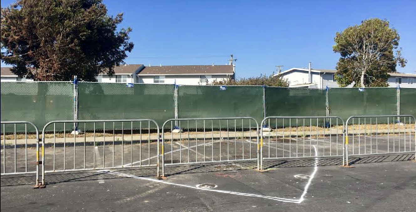
An accompanying photo received by the Bay View newspaper in August 2019 shows a V-shaped white line marking off an area where the Navy planned to dig a huge hole in the parking lot at the fence behind which stretches the footprint of recently razed 1126 Reeves Court.
On Aug. 9, 2019, Navy environmental coordinator Tahirih Linz emailed the Bay View, “That location (1126 Reeves Court) is one of our 41 discrete digs as part of the current Site 12 fieldwork.” Promising she would provide “the specifics of the chemicals of concern for that location,” she reported that the Navy was looking for chemicals called polychlorinated biphenyls (PCBs), and the excavated soil would be scanned for radiation.
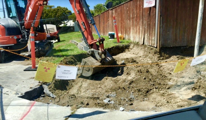
By Wednesday, Aug. 14, 2019, unidentified material appeared to have been retrieved from the “discrete dig site.” The hole had been rapidly filled in, covered with an asphalt cap, and concealed from public view behind green-tarped fencing. Its proximity to the dig site at Ozbourne Court and Gateview Avenue, which displayed a radiation sign, raised alarms about the potential presence of radioactive material throughout the entire area.
Between 2014 and 2019, long-time former residents of the seven 1126 Reeves Court units – A through G – all people of color, began reporting to the Bay View hair loss, cancers, heart failure, asthma, pneumonia and severe lower extremity pain and swelling. Though the strange symptoms they experienced during their extended residency at 1126 Reeves Court made them suspicious, they were given no reason to fear they were being poisoned.
Current tenants renting Reeves Court units expressed concern to the newspaper after they noticed that this PCB-radiation dig was located a short distance across a small parking lot from their homes. They were also worried about the radiation sign next to the dig site at Ozbourne Court and Gateview Avenue. By the following day, the rad sign had been removed and the hole covered with asphalt.
Contamination maps of Treasure Island
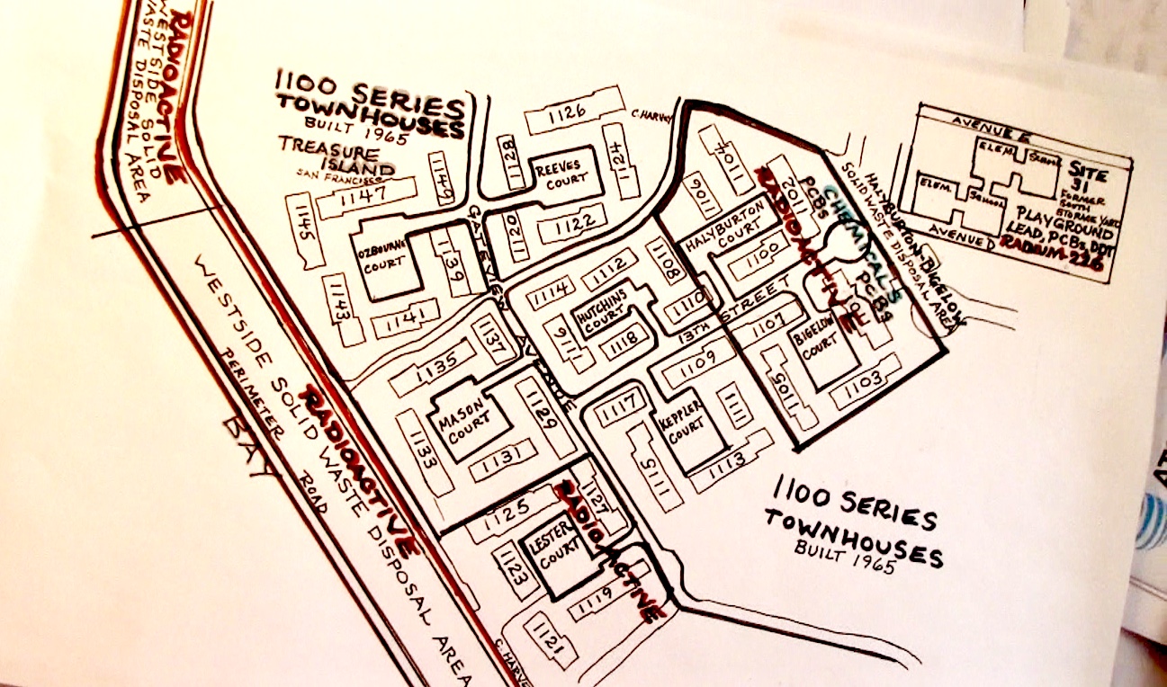
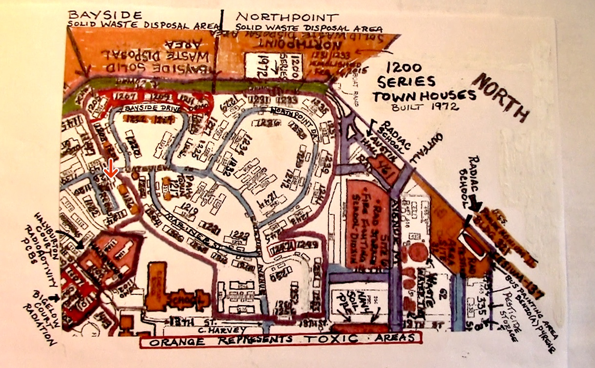
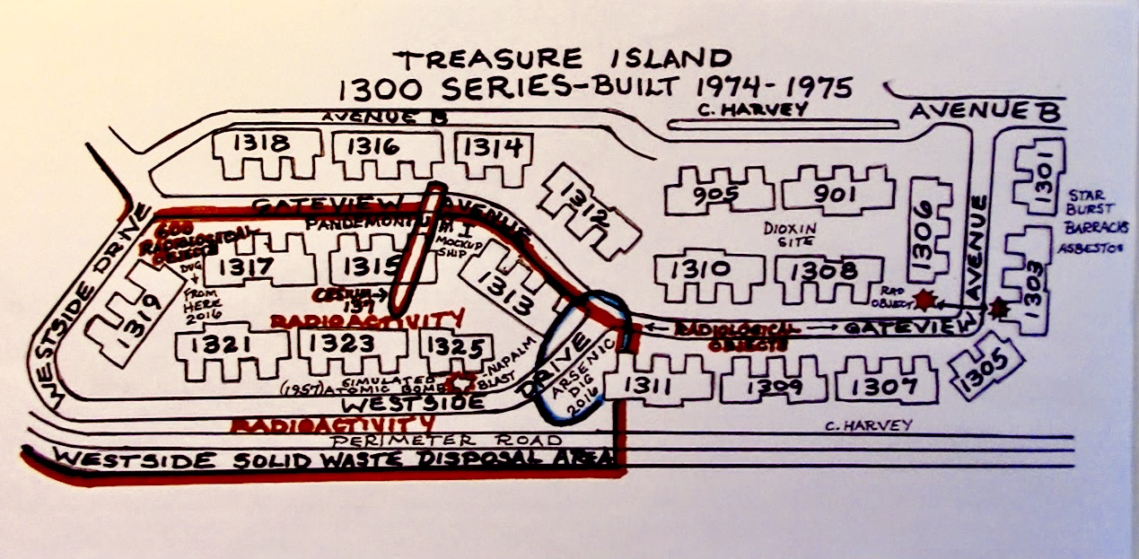
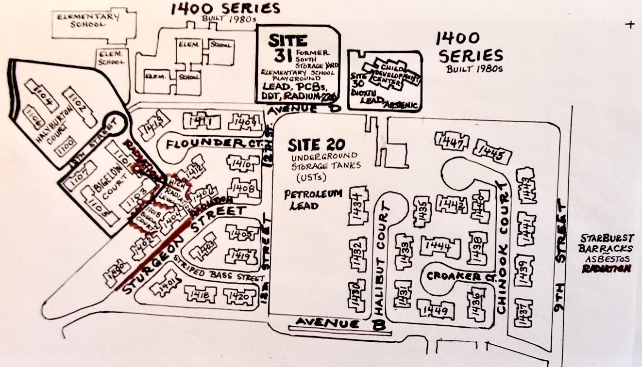
A Navy map taken from the 2006 radiological assessment shows limited toxic areas. A map based on the two corrected 2012-2014 reports indicates the contamination was far more widespread than originally reported.
Maps of the four Treasure Island housing series, 1100, 1200, 1300 and 1400, show that radiation, chemicals and heavy metals were not sequestered solely behind remediation zone fences, but that the Navy has been digging toxins from the entire residential area.
The Navy’s refusal to answer a 2018 Freedom of Information Act request by a Washington, D.C., watchdog group and its under-reporting of the involvement at Treasure Island of ultimate parent company Tetra Tech, Inc.’s subsidiary, Tetra Tech EC, that faked Hunters Point radiation data, taken together with actions such as the rapid concealment of the above toxic sites, forces one to wonder whether the Navy is telling the whole truth about the Treasure Island cleanup. What is the Navy hiding from residents and business owners about toxins on Treasure Island?
Some answers will be provided in Part 3 of this article.
Carol Harvey is a San Francisco political journalist specializing in human rights and civil rights. She can be reached at carolharvey1111@gmail.com.


